

News
On the Forecast? Snow, and a Lot of It.
Just in time for Thanksgiving, slippery roads and treacherous travel conditions.
November 19 2022 12:00 AM EST
By continuing to use our site, you agree to our Privacy Policy and Terms of Use.
Just in time for Thanksgiving, slippery roads and treacherous travel conditions.
(CNN) – As millions of Americans gear up to travel during the Thanksgiving holiday week, the forecast calls for rain, snow, blustery winds, and cold temperatures this weekend at the beginning of the travel rush.
Millions from Minnesota to Maine are expected to see snow this weekend, but rain and thunderstorms will be the main concern across some Southern states.
We’re still 33 days away from the astronomical start of winter (or 12 days away from climatological winter, if that’s your preference), but it will certainly feel like winter as temperatures across almost the entire lower 48 states will be 10 to 20 degrees below normal on Saturday.
Snowplows will be busy this weekend
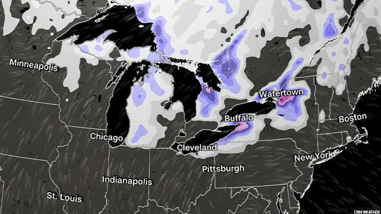
In the last 48 hours, a lot of snow has fallen across the Midwest and Northeast regions. A lot. We’re talking at least a foot of snow in Michigan, Minnesota, New York, and Pennsylvania. And more snow is on the way.
Snow showers will be expected from Minnesota to New York on Saturday, but communities along the eastern side of the Great Lakes will see the most significant totals.
The National Weather Service office in Buffalo, New York is calling for another round of heavy snow Friday night through Sunday night, saying, “crippling lake effect snow storm remains possible during this period.”
Heavy snowfall and blowing snow will lower visibilities at times to just a few hundred feet.
Not all locations along the Great Lakes will see substantial snow amounts, though. The gradient between those with feet of snow and those with just inches will be very tight. Traveling just a few miles will greatly change impacts seen.
Wind gusts will be about 40 to 50 mph on Saturday across the Great Lakes region, taking whatever snow has already fallen and blowing it around, and reducing visibility even more.
By Sunday, snow showers will begin to push into Vermont, New Hampshire, and Maine.
“A wintry pattern will be in place through the weekend with well below normal temperatures, plenty of cloud cover, and some snow showers,” the NWS office in Burlington, Vermont said.
Temperatures across almost the entire Lower 48 will be 10 to 20 degrees below normal on Saturday. This weekend through the holiday week, more than 70 percent of the US population will see temperatures at or below freezing.
Rain and storms for the South
A low-pressure system in the Gulf Coast will bring rain to parts of Texas and Louisiana this weekend. A cold front stretching along portions of southern and eastern Florida will bring showers and thunderstorms.
While it is not expected to be a washout, the rain in Houston, New Orleans, and Miami may lead to some airport delays as well as traffic jams on interstates and highways.
Overall, rainfall accumulations are expected to be around 1 inch or less, but some isolated spots could pick up as much as 3 inches.
Along the panhandle of Texas and eastern New Mexico, temperatures will be cool enough to see a mix of snow and freezing rain.
The first round of precipitation comes Friday night into Saturday morning.
“Guidance suggests the 32 degree mark will generally be along and north of the I-10 corridor, so areas north of there may see a period of mixed frozen precipitation,” the NWS office in Midland, Texas said. “A few spots may see surfaces become wet and possibly icy thanks to falling road temperatures.”
Areas to the south of Interstate 10 will see mainly rain but should still be careful of any wet spots on roads, especially along bridges and overpasses which freeze first.
“The next batch of precipitation comes in during late Saturday night into Sunday morning, but the focus shifts to areas near the I-10/I-20 split and southward over Southwest Texas,” the weather office said. “With models trending towards near and below freezing temperatures, precipitation types will be mostly frozen, leading to a heightened risk of both wet and slick/icy spots.”
New system arrives for the Northwest
The first half of the weekend will be quite pleasant for much of the West Coast, and after a potent Santa Ana wind event earlier this week, they could use a break.
By Sunday, however, that begins to change as a new system pushes into the Pacific Northwest.
“The pattern change will signal a shift back to much wetter weather for next week,” the NWS office in Portland, Oregon, said.
The first of several systems will arrive Sunday night into Monday with additional fronts Tuesday and Wednesday of next week, leading to a very wet pattern for this region ahead of the Thanksgiving holiday.
Areas of Washington and Oregon will begin to see cloud cover increase and rain chances begin by dinnertime Sunday, and conditions will continue to deteriorate Sunday evening.
“This first system will be the weakest one in the extended,” the NWS office in Seattle said. “System arriving Tuesday more consolidated than the system on Monday for more rain for the area.”
The system on Wednesday is looking like the most robust of them all. Forecast models suggesting a possible atmospheric river scenario which could bring several inches of rain to the Pacific Northwest region.
Stay tuned through the weekend as we will keep you posted on the biggest holiday weather concern Wednesday to Friday of next week.
The-CNN-Wire
™ & © 2022 Cable News Network, Inc., a Warner Bros. Discovery Company. All rights reserved.