News
Black Friday Travel Could Be a Big Headache This Year

Possible storms might make for a wet and wild weekend.
November 24 2022 12:00 AM EST
By continuing to use our site, you agree to our Privacy Policy and Terms of Use.

Possible storms might make for a wet and wild weekend.
(CNN) – Thanksgiving is here and whether you hit the road or took to the skies, hopefully you’ve made it to your destination with minimal headache. Thanks in large part to the relatively quiet weather so far this week, airlines have reported minimal delays and cancellations.
Unfortunately, that could change in the coming days as a more active weather pattern takes shape over the eastern US.
But first, some good news. The weather for the Macy's Thanksgiving Day Parade looks excellent. Mostly sunny skies are in store and most importantly, the winds will remain light so there shouldn't be any restrictions on the balloons.
Soggy Thanksgiving Day for the South
The active weather gets underway in the Southern Plains on Thanksgiving Day.
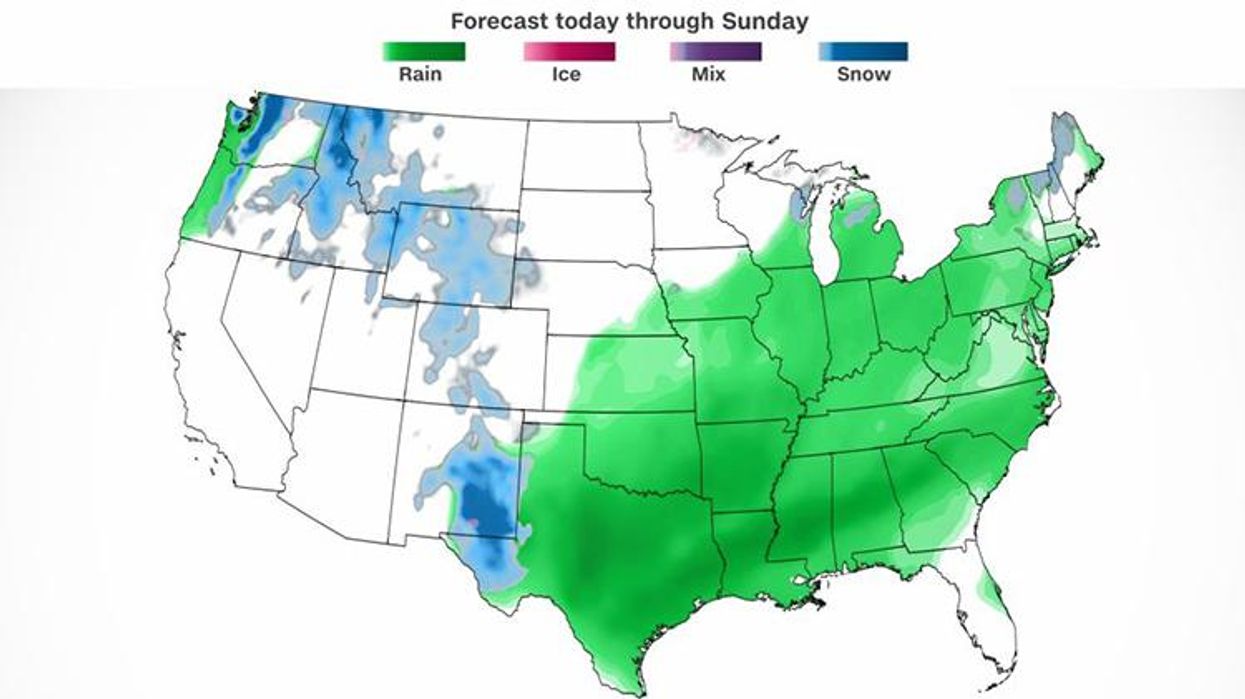
“The main area of concern heading into the Thanksgiving holiday will be the potential for a dynamic low-pressure system to impact portions of the Southern Plains and Lower Mississippi Valley with heavy rainfall, snow, and thunderstorms,” the Weather Prediction Center said.
Cities including Dallas, Houston, New Orleans, Memphis, Tennessee, Shreveport, Louisiana, and Little Rock, Arkansas, will all experience rain and the chance for thunderstorms as we head through the day which could impact any outdoor cooking plans.
While the timing of the rain may not be the best, nearly 70 percent of the South continues to be in drought, so the rain will be beneficial. Widespread totals of 1 to 2 inches with isolated higher amounts are expected from eastern Texas to Mississippi.
Rain showers will spread northward along a cold front late Thursday afternoon and into Thursday night for the Ohio Valley and Great Lakes. This rain will be more scattered and much lighter compared to the Lower Mississippi Valley.
The heavier rain from the Mississippi Valley spreads through the Deep South Thursday night and Friday morning while the light rain in the Ohio Valley spreads into the Northeast. The majority of this rain will push offshore by mid-afternoon Friday.
While the Western US will experience quiet weather for Thanksgiving Day, Southern California is expecting another Santa Ana event which will bring elevated fire conditions to the Los Angeles area, especially the San Gabriel Mountains into the Ventura Valley. Wind gusts are expected to top 40 mph and may even reach 60 mph in some of the higher terrain. These winds will combine with low relative humidity to produce adverse fire conditions.
Weekend storm develops, brings snow to West Texas
As the rain pushes east, the stubborn upper level low will bring temperatures cold enough for snow in portions of western Texas.
“The backside of the upper low over the southern High Plains should have sufficiently cold air to produce impactful snow accumulations to portions of eastern New Mexico and far West Texas beginning Thanksgiving night and lasting into Friday,” the Weather Prediction Center said. “Snow accumulations of 3 to 8 inches, with locally higher amounts especially in the higher terrain, are possible with hazardous travel conditions likely.”
“There’s still some uncertainty with respect to the timing and placement of the heaviest snow band associated with this system, but folks doing holiday shopping or traveling within the Texas Panhandle should consider impacts from the snow on Thursday night-Friday morning,” the Weather Prediction Center said.
“We have the potential with the banding of snow where one area may get little to no snow, and over a short distance, another area may get several inches of snow,” the National Weather Service in Amarillo said.
Farther east, it will be all rain in central Texas Friday. The rain will spread into East Texas and the Lower Mississippi Valley late Friday and Saturday as the snow ends. Another widespread 1 to 2 inches is expected, bringing some locations up to 4 inches between Thursday and Saturday.
Sunday’s busy travel hampered by rain in the East
Saturday night the rain will again push east into the Ohio Valley and the Deep South.
Through the day on Sunday the rain will continue to move farther east, impacting much of the Eastern Seaboard from northern Florida to New England.
This is likely to bring travel delays to many of the major hubs, from Chicago, Detroit, and Charlotte early in the day, to New York, Philadelphia, and Washington for the afternoon.
While the rain is expected to bring travel delays to the East Coast, very little snow is expected this time around.
“The good news is temperatures should be warm enough that nearly all the precipitation will fall as rain in the US, but the bad news is the rain and strong winds will make for wet roads and potentially long airport delays on Sunday for the major hubs in the Northeast,” CNN meteorologist Dave Hennen said.
The-CNN-Wire
™ & © 2022 Cable News Network, Inc., a Warner Bros. Discovery Company. All rights reserved.